 Family
history Family
history
|

|

|
|
|
HALE NAME DISTRIBUTION IN 1881
There were 10,795 people with the HALE surname found living in Great Britain at the time of the 1881 census.
There were nearly double that amount - 19,260 - if all 17 variations that we found are included.
These are NOT included in the figures below and will be the subject of a subsequent page.
Naturally there were more HALEs living in counties with very large populations e.g Middlesex and Surrey - both of which encompassed large parts of London - industrial Staffordshire with its Potteries in the north and heavy industry in the south, and Lancashire with its cotton mills.
Semi-rural Gloucestershire with its relatively small population was the notable exception,
having the second largest total.
These are the only five counties containing more than 500 HALEs, with Middlesex/London, Gloucestershire and Staffordshire breaking the 1,000 mark.
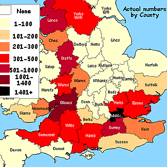
This map shows that the greatest number of HALEs (1,465) was in Middlesex/London [Of these only 764 were born in the area.] |
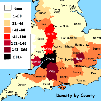 The greatest density as a proportion of the population was in Gloucestershire (233 per 100,000) |
++++++++++++++++++++++++++++++++++++++++++++++++++++++++++++++++++
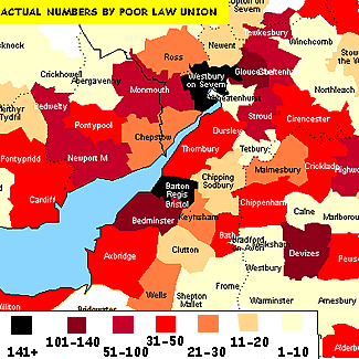
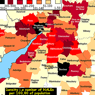
Within counties themselves there were also variations. Measured by Poor Law Union - which is closely related to Registration Districts - it can be seen that Westbury-on-Severn in the Forest of Dean was the area most densely populated with the name. (246, or 1044 per 100,000)
Although there were actually more HALEs in a heavily industrialised area - Dudley, Staffordshire* (463 - not shown on the map,) they represented a smaller proportion of the local population than in Westbury or in six other areas.
Barton Regis (the Clifton area) with 372 was second to Dudley in actual numbers with Devizes, Wiltshire runner-up in density to Westbury.
|
|
The actual numbers of HALE names (no variations)in 1881 by County were : Position County Actual No. Per 100,000 1 Middlesex 1465 50 2 Gloucestershire 1348 233 3 Staffordshire 1030 100 4 Lancashire 927 26 5 Surrey 701 49 6 Wiltshire 434 168 7 Essex 384 67 8 Somerset 351 75 9 Worcestershire 350 92 10 Hertfordshire 337 166 11 Yorks W.Riding 310 14 12 Hampshire 308 59 13 Warwickshire 296 40 14 Cheshire 266 41 15 Kent 254 26 16 Monmouthshire 230 109 17 Suffolk 164 46 18 Northumberland 137 32 19 Glamorgan 133 26 20 Sussex 121 25 21 Berkshire 121 55 22 Co. Durham 109 13 23 Lincolnshire 94 20 24 Derbyshire 88 19 25 Devonshire 83 14 26 Bedfordshire 81 54 27 Northamptonshire 80 29 28 Oxfordshire 70 39 29 Cambridgeshire 67 36 30 Nottinghamshire 56 14 31 Yorks N.Riding 55 16 32 Norfolk 52 12 33 Isle of Wight 47 64 34 Buckinghamshire 42 24 35 Cumberland 37 15 36 Leicestershire 36 11 38 Yorks E.Riding 34 11 39 Shropshire 23 9 40 Huntingdonshire 22 38 41 Lanarkshire 20 2 42 Ayrshire 19 9 43 Dorset 18 9 44 City of London 17 33 45 Pembrokeshire 14 15 46 Westmorland 13 20 47 Herefordshire 11 9 48 Clackmannanshire 8 33 49 Anglesey 7 14 50 Flintshire 6 8 51 Isle of Man 6 11 52 Jersey 5 10 53 Guernsey 5 16 54 Carmarthenshire 5 4 55 Wigtownshire 5 13 56 Stirlingshire 5 5 57 Midlothian 5 1 58 Rutland 5 23 59 Cornwall 5 2 60 Breconshire 4 7 61 Aberdeenshire 3 1 62 Roxburghshire 2 4 63 Denbighshire 1 1 64 Caernarvonshire 1 1 65 Shetland Isles 1 3 66 Kirkcudbrightshire 1 2 67 East Lothian 1 3 68 Dumfriesshire 1 2 69 Bute 1 6 70 Argyllshire 1 1 71 Angus 1 0 72 York 1 2 |
The density by Poor Law Union was: County Poor Law Union Actual per 100,000 GLS Westbury on Severn 246 1044 WIL Devizes 140 682 GLS Tewkesbury 59 454 HRT Royston 92 373 HRT Bishops Stort. 76 348 WIL Cricklade 39 345 HAM Droxford 38 339 STS Dudley 463 330 HRT Hertford 55 328 MON Monmouth 95 313 HRT St Albans 63 270 WIL Pewsey 33 266 ESS Halstead 44 259 GLS Dursley 32 255 WOR Evesham 39 255 GLS Gloucester 117 250 SFK Sudbury 73 242 STS West Bromwich 300 238 SOM Williton 44 235 HAM Alton 34 224 GLS Barton Regis 372 224 GLS Stow on the Wold 20 219 HAM Fareham 36 215 WAR Shipston on Stour 38 212 SFK Risbridge 36 209 GLS Cirencester 43 202 SOM Bedminster 136 202 GLS Thornbury 34 199 WIL Malmesbury 25 179 HRT Ware 33 177 WIL Chippenham 38 177 GLS Tetbury 10 170 MON Bedwelty 95 170 WIL Highworth 60 168 HEF Ross 26 159 GLS Stroud 64 155 HAM Basingstoke 29 150 MON Chepstow 26 139 SOM Wells 30 136 ESS Colchester 38 134 GLS Cheltenham 72 130 HAM Stockbridge 9 129 LAN Ormskirk 107 129 HUN St Neots 21 124 ESS Epping 27 124 SFK Bosmere 19 123 GLS Bristol 71 123 GLS Newent 13 121 WIL Alderbury 32 118 BRK Cookham 19 112 BRK Easthampstead 14 111 WOR Worcester 36 111 MON Pontypool 39 110 HRT Berkhampstead 16 106 SOM Axbridge 43 106 LND Stepney 62 106 LAN Chorley 50 105 MON Newport M 74 105 CHS Wirral 29 104 STS Walsall 87 103 GLS Northleach 10 102 BRK Hungerford 18 101 WAR Meriden 11 100 All of the remaining, un-named, Unions had fewer than 100 HALEs per 100,000 of the local population. |
 |
 |
 |